Parameters for instruments
On this page the functionality of the instruments can be individually adapted. The parameters of these instruments can be modified:
- GPS / position visualization
- altimeter
- visual climb rate meter
- acoustic variometer
- terrain instrument
- ground speed meter
- accelerometer
- indicator for waypoints
- distance indicator to airspaces
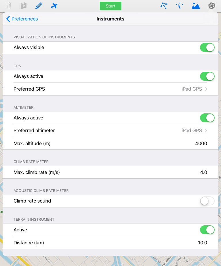
On the top locating the current position by the built-in GPS can be activated even when no track points are saved. The position values are shown on the logging page. Also a selection of the to be used GPS can be made.
In the second section it can be selected if the altitude is measured although no flight tracking takes place. Furthermore, the user can select which height is being shown, either the GPS height or the height of an external connected altimeter. The third row indicates the maximum visualized altitude value (shown by a horizontal bar) for the altimeter instrument. The standard value is 4000 m.
Remark: Independent from the selected instrument for the height visualization both heights - if available - are saved. If an external device is not connected the internal GPS is used as a fallback.
Touching the edit button on the upper right climb rate dependent tones can be individually generated, modified and deleted. Touching a tone sequence selectes it (editing disabled).
Remark: The standard tone sequence cannot be modified nor deleted.
The terrain instrument can be activated or deactivated in the following section. If the terrain indicator is activated also the shown distance for the profile can be selected.
The measurement frequency of the accelerometer can be set to values between 1 Hz and 100 Hz. The default value is 10 Hz.
Note: If the measurement frequency is too high for the type of iPhone or iPad the logging screen may freeze!
The fourth parameter in the same section allows the activation of an acustic signal when flying into a waypoint cylinder.
The last two sections are used for modifying the parameters for the distance indicator for airspaces. If no airspace is within the far distance, the distance indicator does not show anything. If the pilot is between the far and the near distance range relative to an airspace, the distance indicator shows a green colour in the direction of the airspace, between the near and the close distance a yellow and otherwise a red colour.
The default values for the lateral distance are for the far distance range 2 km, 1 km for the near and 500 m for the close distance range.
The far altitude distance height has a value of 400 m, 200 m for the near and 100 m for the close height distance range.
Additionally, a signal can be enabled for each range that is activated whenever a range is entered.
Remark: The signal is only activated when the pilot enters a range that indicates a closer approach to an airspace than the one from which he is coming from.